Saxon Times to 20th Century
The Beginnings
Louth originated in Saxon times either side of the River Lud where it crossed by the ancient trackway along the east edge of the Wolds. The name derives from Hlud or Loud, referring to the fast flowing river that powered up to 13 watermills. The Danes left their mark in today’s street names, where gata means ‘a way’: Chequergate, Cisterngate, Eastgate, Westgate and Upgate. With Cristianity came St. Mary’s Church, on the site of the Old Cem, and the first Church on the site of St. James’s.
At the time of the Domesday Survey in 1086, Louth had a population of about 600, and was one of the only five boroughs in Lincolnshire and of only fifty markets in England. As lord of the manor, the Bishop of Lincoln created a planned town east of Upgate with a large open space for a market, now divided by the buildings between Mercer Row and the Cornmarket.
As Louth’s importance grew as the trading centre between Wolds and Marsh, by 1300 the population had grown to 2,000 and there were two annual 8-day fairs. Farmsteads were in the town, the two parish hedgeless open fields, North and South, were ploughed in the furlong strips by the oxen and horses, and there was common grazing and meadow pasture by the river east of the town, all controlled by the Manorial Court. This communal farming system survived until the beginning of the 19th century when Parliamentary enclosure created today’s familiar pattern of fields and hedges.
Louth Park Abbey
The abbey at Louth Park just east of the town was founded in 1139. The Cistercian Order had a reputation as sheep farmers and the income was devoted to building a large cruciform abbey church. Chalk from Louth quarries and sandstone from the Wolds was floated along the Monks’ Dyke which carried water from St. Helen’s spring in the Gatherums to the abbey fishponds. When completed in the first half of the 13th century, it was nearly as wide as Lincoln Cathedral and 70 feet longer than St. James’s Church. The abbey complex housed a community of 66 monks and around 150 lay brethren.
The Black Death
East Lindsey in the early 14th century suffered famine and distress from coastal flooding and heavy rains. Then came the summer-time disease born by the fleas of the black rat – the Black Death. The chronicler of Louth Park Abbey wrote: ‘In the year of our Lord 1349 the scourge in many places left less than a fifth part of the population surviving’. Among them was the abbot, William de Luda.
Wealth from Wool
The prosperity of Louth merchants owed much to the long staple of sheep reared on the Wolds and grazed on the ‘rich fatting pastures’ of the Marsh. This led to the building of the great parochial church in the Perpendicular style. The 13th century church of the St. Herefrith was lengthened and widened in the 1440’s, and rededicated to St. James. The Bishop of Lincoln, as lord of the manor, and the rector paid for the chancel, and the people’s nave held seven chantries and altars, a three-storey rood screen with an organ, and even an equestrian statue.
The crowning glory of the spire soaring to 295 feet was built of Ancaster limestone between 1501 and 1515. The cost – £305 8s 5d – came from collections, burial and bell-tolling fees and gifts from the devout.
The Lincolnshire Rising
The dissolution of Louth Park Abbey in September 1536 brought home to the people of Louth the meaning of what Henry VIII was doing in seizing property. The parish church, then Roman Catholic, had many precious vessels and vestments, and rumour was abroad that the King wished to seize them also. On Sunday 1st October at High Mass and at Evensong the vicar, Thomas Kendall, warned the congregation of an impending visit by the Bishop’s steward.
Next morning an armed and unruly mob was about in the town, and two commissioners who were dissolving the nunnery at Legbourne were seized and put in the stocks. The rising or rebellion – for such it was – rapidly spread to Horncastle and Caistor and 30,000 men marched on Lincoln. Their petition to the King was rebuffed with the famous words ‘ye rude commons of one of the most brute and beastlie shires in the whole realm’. Some of the rebels were executed in Louth Market Place, but the ringleaders, including the vicar, were taken to Tyburn on the outskirts of London to be hanged, drawn and quartered.
Only fifteen years later, Henry’s successor, King Edward VI, had a different view of Louth. For him it was ‘a place most proper and fit for teaching and instructing lads and youth’, and in September 1551 he granted the charter to found the Free Grammar School which still bears his name today.
The Green Lady of Thorpe Hall
Tradition has it that a Spanish lady dressed in green haunts the grounds of Thorpe Hall on the outskirts of the town. Who was she? The story goes back to 1596 when John Bolle of Thorpe Hall was knighted for his valour in the defeat of the Spanish navy at Cadiz. During his thirteen days there a high born Spanish lady was assigned his prisoner, and she fell in love with him – but he remained a faithful husband. When Sir John sailed for home the senorita sent gifts for his wife, among them her portrait drawn in green, and then she retired to a convent.
Civil War and Years of Sleep
With the 17th century came the Civil War. The King commanded Sir Charles Bolle to raise eighty troopers, but after a skirmish near Louth, Parliamentary troops subdued the town and took a hundred prisoners. As for Sir Charles, he hid under Ramsgate bridge to avoid capture. Oliver Cromwell on the other hand is said to have slept in Louth before the decisive battle at Winceby near Horncastle.
The 1660’s and 1750’s are sometimes called the years of sleep in Louth. However, law and order was strictly enforced in the House of Correction, the prison on Eastgate (on the site of the almshouses) with a treadmill for miscreants. The town welcomed immigrants from Europe. And the Corporation built the Assembly Rooms or Mansion House on Upgate for their meetings and where there was also entertainment.
Turnpike and Canal
Louth had for long been the hub of a network of roads, but it was not until the second half of the 18th century that turnpike or toll roads were established. The most important was the Dexthorpe Turnpike – south to Boston and Peterborough and west to Gainsborough and Bawtry. Other turn pikes were to Lincoln, Grimsby, Saltfleet and Horncastle; the toll house for the last is still there near the bypass.
Coal and timber were imported and corn and wood exported through Saltfleet and Grimsby until the opening in 1770 of the eight-lock Navigation Canal from Tetney to the Riverhead. This became Louth’s dockland, separated from the town by green fields. Within fifty years it was an industrial suburb with wool and grain warehouses, maltkilns and breweries, ropery and soapery, woodyard and tannery, fertilizer factories and shipyard. Sloops, billy boys and keels were towed by horses or sailed in from the Humber.
To Market
Louth was – and is – a major market town serving a wide hinterland of Wolds and Marsh. Before the mid-18th century much of the Wolds were open downland and rabbit warrens. Then came rotation of corn and roots and the wide-verged roads became droveways for beasts on their way to Louth Cattle Market. At the west end of the Cornmarket stood the mid-19th century Corn Exchange, and some eighty carriers and their carts from fifty villages converged on Louth for the Wednesday and Saturday markets. The horse was the power on the farm and on the road, and most of the town’s inns had stabling and a haystack.
Growth and Decline
The first sixty years of the 19th century saw dramatic changes in the town. The population doubled to over 10,000 the old Corporation was replaced by the Borough Council, industry expanded with foundries and a carpet factory, and the town was lit by gas. And there were many new public buildings – the first Holy Trinity and St. Michael’s churches, six chapels, four Church of England schools, a new grammar school building, a Wesleyan school and the non-denominational Kidgate School. This period also saw the establishment of the Union Workhouse (1837), a new Town Hall (1854) and the Market Hall (1867) which looks like King’s Cross railway station.
The railway through Louth opened in 1848 and within thirty years there were branch lines to Bardney and Lincoln (1876) and to the seaside at Mablethorpe (1877). However, the last forty years of the 1800’s saw farming depression and emigration to America and Australasia. In fact the town’s population fell by nearly a thousand
Culture Capital
Throughout the changing fortunes of the 19th century, Louth became established as the culture capital of east Lincolnshire – in music, literature and the visual arts – a title it still holds today. Thomas Wilkinson Wallis became a nationally acclaimed woodcarver, and in 1844 William Brown sketched the town from the top of scaffolding surrounding the spire of St. James’s to create the internationally important Panorama which now hangs in the Town Hall Council Chamber. The artist and architect Thomas Espin built the Priory and his own mausoleum in the grounds. And that most prolific of architects James Fowler was responsible for at least twenty buildings in the town, the design of 26 new churches in Lincolnshire and beyond, and the restoration of many more, including St. James’s.
In literature the town is proud to be associated with Alfred Tennyson – through family connections and because he went to the Grammar School here, but, by his own account, he hated every moment of it. His only solace it seems were the wild weeds growing (as they still do) on the wall in Schoolhouse Lane, but his first poems were published in Louth and he rose to be Poet Laureate. In music Charlotte Alington Pye, daughter of a Louth Lawyer, took the pseudonym Claribel from the title of one of Tennyson’s early poems, and became the country’s most successful and prolific ballad composer.
Twentieth Century
Edwardian Louth saw the foundation of a girls’ grammar school on Westgate in 1903, the gift to the town by the Pahud Trustees of Hubbard’s Hills as a riverine public park (1907), a museum provided by the Louth Naturalists’, Antiquarian and Literary Society (the ‘Ants and Nats’) in 1910, and electric lighting superseded gas in 1919. Monk’s Dyke School opened in 1929 and three years later so did new accommodation for the Boys’ Grammar School on Edward Street.
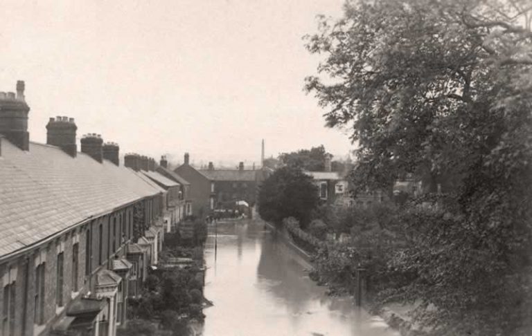
Teatime on Saturday 29th May 1920 saw the disastrous flash flood when, within twenty minutes, the River Lud cut a swathe of destruction through the town and drowned 23 people aged 1 to 82. Yet at the height of the flood, with water lapping an upstairs bedroom, a baby girl was born. Fifty homes were destroyed and another 250 had to be rebuilt. Flood marker stones on surviving buildings are a dramatic reminder of the depth of the flood water.
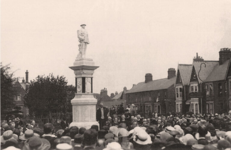
Two World Wars claimed the lives of 286 servicemen and women and 15 civilians from bombing in the 1939-45 conflict. Postwar Louth grew slowly in size and prosperity again: a new secondary school was built – Cordeaux (1956), other schools expanded into new buildings, the Workhouse which had become the hospital from 1938 was extended, and next to the railway station there appeared (1951) a new high-rise and high-tech concrete maltkiln (no longer there, stood where the Aldi Car Park is now situated). Sadly the town lost its rail services between 1951 and 1970, but the A16 bypass (1991) brought traffic relief to Upgate, and light industry spread on the Fairfield Estate on the north side of the town.
Find out more about our lovely town of Louth at the Museum on Broadbank.