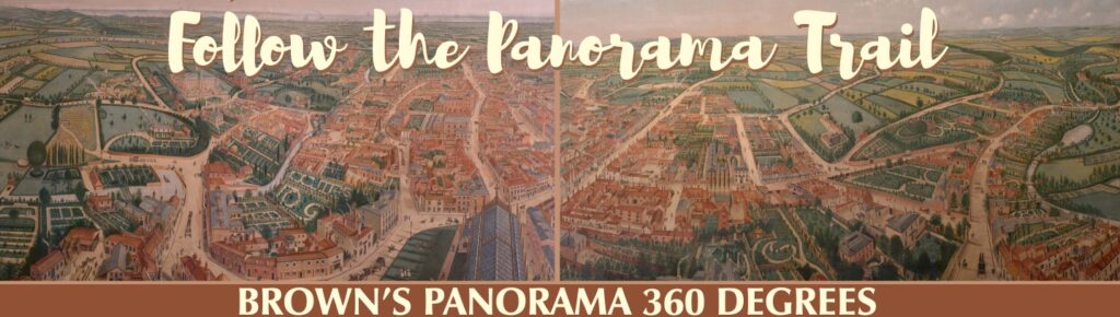
Brown’s Panorama Trail
Brown’s Panorama is a bird’s eye view of Victorian Louth and the surrounding area, framed in the time capsule of a busy, sunny day, a remarkable 360 degrees panorama, a snapshot in time. The term Panorama comes from the Greek meaning ‘all embracing view’ and Brown intended the viewer to feel as if the features of Louth had been placed before the eye at a glance, as if the spectator had the flight of an eagle.
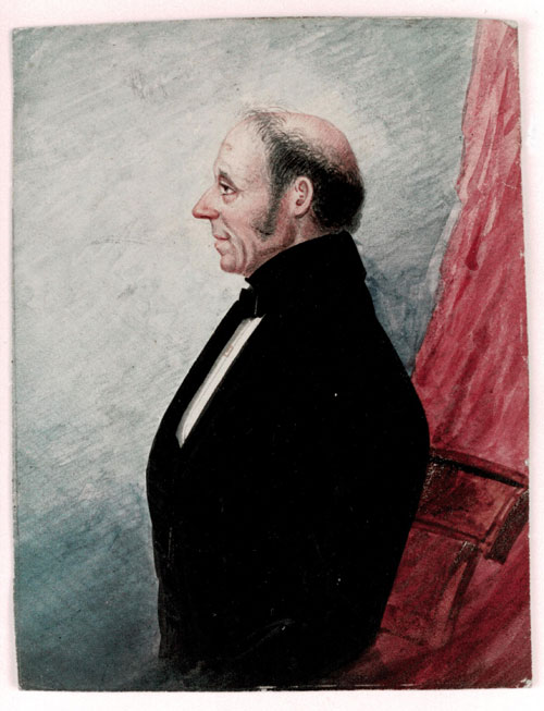
William Brown was a family man, married three times. He fathered 14 children, all by his first wife, but only five lived to adulthood and only two outlived him. The Brown family lived at the Northgate end of Vickers Lane, and William was an active member of the local community. He was a Methodist preacher and teetotaller, and faithfully recorded life as the local correspondent for the ‘Lincoln Rutland and Stamford Mercury’ newspaper, a position he held from 1839 until his death. For most of his life he made his living as a housepainter.
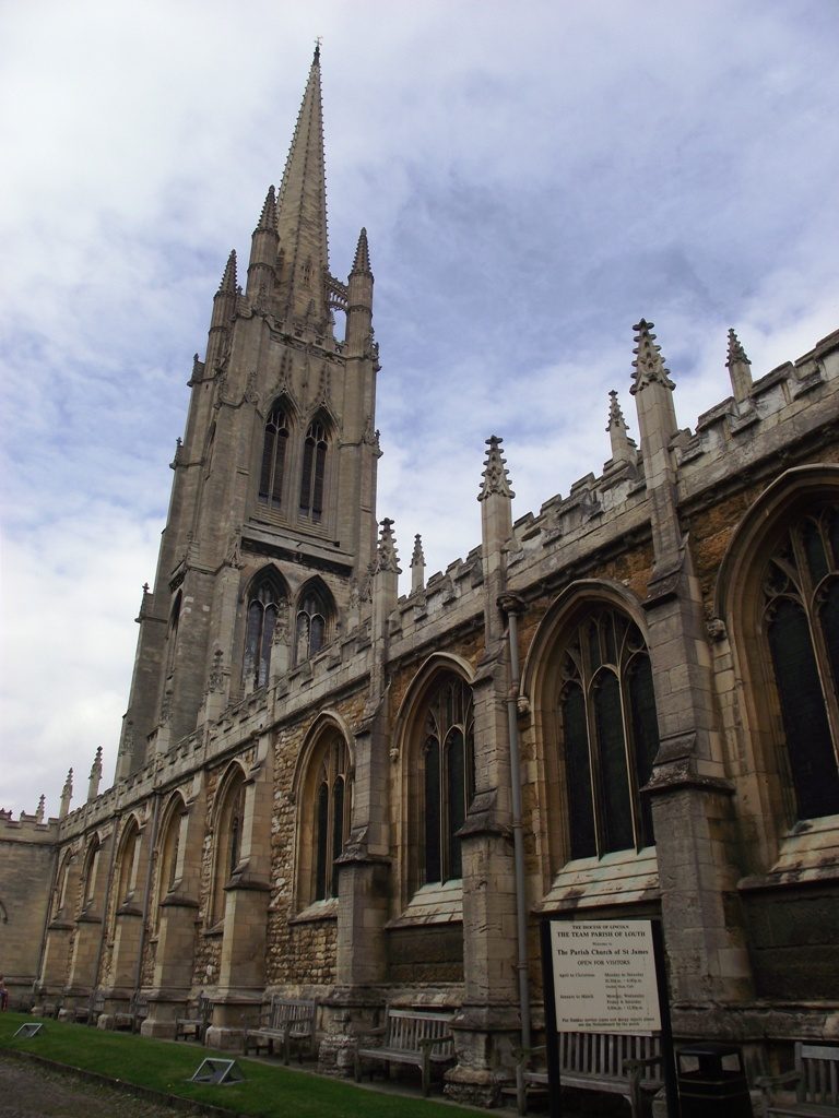
In 1844 St. James’ Church spire was struck by lightning and it is said that the tower and spire were split from top to bottom. Apparently, inside the church the fissures were large enough for the countryside beyond to be seen. Brown seized the opportunity to ascend to the highest point in the landscape, using the scaffolding erected to repair the structure, from which to sketch the surrounding landscape on 7 panels of 51 degrees each and then he transferred his drawings to two six foot by 9 foot oil on linen canvasses. Brown was 56 years of age when he began the transferral process and it took him two years to complete the original canvasses.
Today, the street layout in the town has hardly changed since medieval times. From pieces published by the ‘Stamford Mercury’ newspaper, it is thought that Brown intended to produce postcard-size versions of the painting to sell to locals and this is why he went to so much trouble to include named buildings and people on the painting, in the streets or in their gardens. The postcard scheme came to nothing. But the intricate detail and accuracy employed by Brown render his Panorama a valuable historical record. And, once he had completed the painting he did not leave it alone but tried to keep it up to date, painting out things that had been demolished such as windmills and painting in new buildings like the Town Hall, not built until 1854.
The Panorama was first exhibited in Louth Mansion House in 1847, and again in 1856 in Louth Corn Exchange. However, in 1988 the Panorama formed part of an exhibition at the Colnaghi Art Gallery in London, and the wider world gave it eulogistic recognition.
Sadly, Brown died in 1859 and it is said that at that time he was walking around with a tumour in his chest that weighed 14lbs.
After his death in 1859 the paintings disappeared, not to be found again for 92 years when in 1948 the then Mayor of Louth, Wilfred Alex Slack happened to meet Mrs. Whitehead, the wife of the vicar of Alford who said she had two ‘pictures’ which he ought to see. The ‘pictures’ were in bad condition but the Mayor realised that the paintings had to be bought for the town and restored. With the help of a National Art Collections Fund grant and public subscription this was achieved.
In 2007 the paintings were cleaned and restored and now hang on display in Louth Town Council’s Old Court Room. A back lit digital replica of the Panorama is also on public view at the Louth Museum.
The information boards which accompany this Brown’s Panorama Trail leaflet are displayed around the town of Louth, created by Louth Town Council and funded by The Welcome Back Fund. The Welcome Back Fund allows Councils to work with their communities to put in place additional measures to create and promote a safe environment for local trade and tourism. The aim is that residents and visitors alike can follow the trail around Louth, reading the displays which will impart historical facts about the areas in which they are situated, encouraging viewers to find out more about the wonderful Brown’s Panorama and as an added bonus, following the trail allows the viewer to enjoy fresh air and space.
We are grateful to East Lindsey District Council for their support; to the Louth Naturalists’, Antiquarian and Literary Society (LNALS) and to Dr. Richard Gurnham for assistance in creating the information boards. Further reading/information: ‘William Brown and the Louth Panorama’ by David Robinson and Christopher Sturman, ‘The People of the Panorama’ by Dr. Richard Gurnham. Both these books are available to purchase from Louth Museum and local bookshops.
Follow the Panorama Trail
Use the map to follow the trail. The information board at each location will show a relevant section of Brown’s Panorama, along with pertinent notes of interest (locations listed on the map). You can either use the text on this website or download the Trail Booklet below.
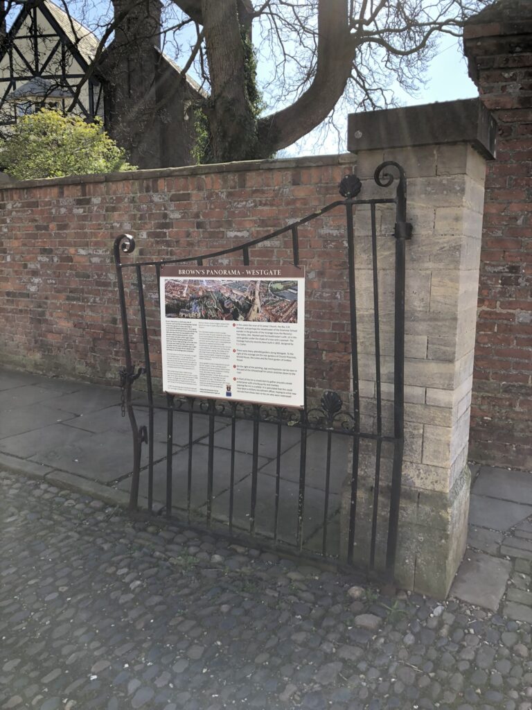
1 Westgate
We begin the Panorama Trail at St. James’ Church, where William Brown climbed the ladders up the spire with his paper and pencils in hand and made a series of sketches looking over the market town of Louth. Near the church a gentleman with a telescope is looking up at the church spire, perhaps watching Brown as he sketched. Along Westgate Brown painted a busy scene; pigs and haystacks can be seen in the yard of the Wheatsheaf Inn and outside men are working on the road, one man entertains passers-by playing music and walking with a monkey. In the garden of The Limes the gardener rolls the gravel. Further along, a groom prepares a horse for his master. Horse-drawn carriages pass by, heading for trouble on Westgate as the workmen have dug a hole in the road! Let us follow the carriages along the road towards Schoolhouse Lane. Please turn left onto this road and you will pass the original site of the Grammar School (on your left) where Alfred, Lord Tennyson, appointed as a poet laureate by Queen Victoria in 1850, went to school. Today, on the wall is a blue plaque commemorating him, which includes a quote believed to be directly related to Alfred’s experiences at the school. On the painting, children play in the playground, but outside on the road, carriages and horses ride along, one child plays with a hoop and a second pulls a dog along on a lead. At the junction turn left onto Gospelgate, once called Goosepool.
2 Gospelgate
As you walk along Gospelgate, you will pass George Street on your right; Brown painted in the housing development on George Street which was built shortly after he made his original sketches. On the corner was the George Inn, part pub/part private residence. A horse appears to be rearing up giving its rider a bit of a fright! Carry on along Gospelgate until you reach the main road. On this corner is the Greyhound Inn, formerly known as the White Hart. In the yard there seems to be some trouble between an amorous man and lady. Nearby a man sits happily on a bench drinking out of a bottle. Turn left and pass Mercer Row (across the road) on your right. Pass the Indian Restaurant, which is believed to be the oldest house in Louth, and where it is said that a poltergeist once haunted an upper room. Carry on down this road.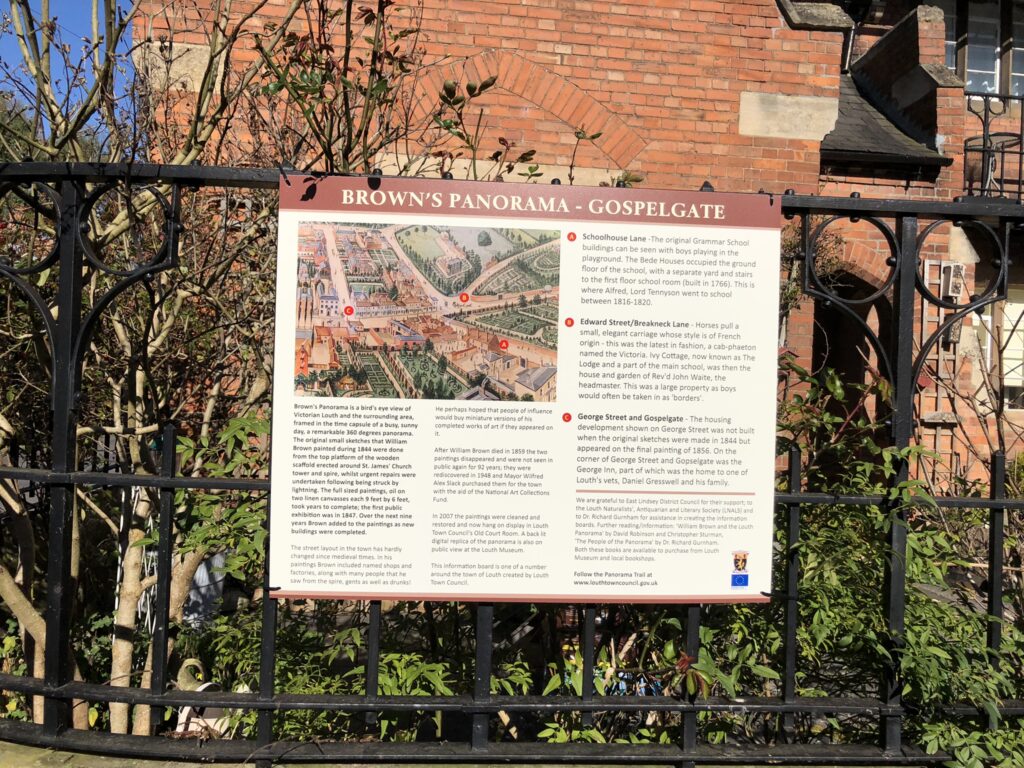
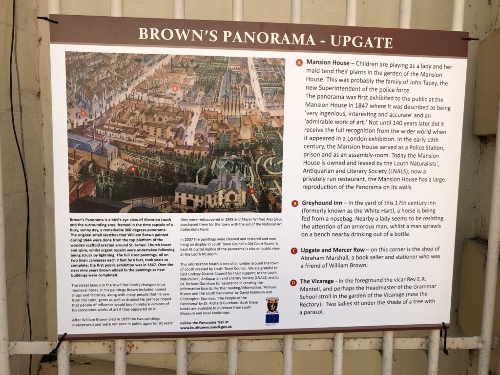
3 Upgate
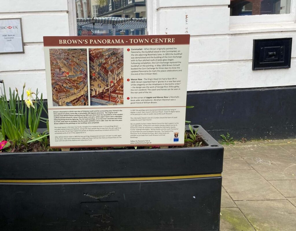
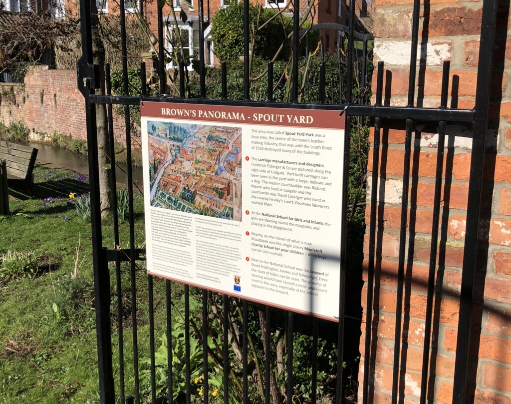
The Mansion House, which became the Mechanics Institute, subscription library and reading room, is now a private restaurant. In Brown’s time it was also the site of the original Police Station and assembly rooms where Superintendant Tacey was in charge. Nearby policemen carry a drunk on a stretcher off into the Police Station. Turn back the way you came and cross the road on the zebra crossing. Located on the southern corner of Upgate and Mercer Row was the shop of Marshall the printer and book seller; it was demolished in 1912 when Upgate was widened. This corner was known as Blue Stone Corner because for many years the corner of the building was protected from being damaged by passing vehicles, by the presence of the large blue stone. The blue stone was thought to have been carried here from northern Britain by ice-sheets that formed. The valley that is Hubbard’s Hills was cut by torrents of glacial meltwater during the last ice age about 40,000 years ago, and it is thought that the blue stone, now on view outside Louth Museum, came down at that point. Carry on along Mercer Row and you pass the King’s Head, which in 1839 had received a Gothic style face-lift. Cross over the road and walk down the cut through known as Butcher Lane, into the Cornmarket.
4 Town Centre
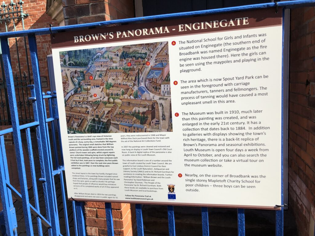
Much of the architecture in the town centre has remained unchanged, look up above the shop fronts; so many buildings are the same ones that Brown saw from his viewpoint at the top of the church. On the north-western corner of the Cornmarket (now the Halifax) is the site which was once the Corn Exchange with four pitched roofs of plate glass, built after Brown made his original sketches, and so it replaced the Guild Hall that had been on the painting. Walk down the side of the Halifax, along Rosemary Lane onto Eastgate. Across the road is the Town Hall, built in 1854 after Brown made his original sketches and added to the panorama. Walk down Cannon Street by the side of the Town Hall, passing the Cinema, which in Brown’s day was the site of a Chapel, and cross over Northgate onto Broadbank. On the left-hand corner there used to stand the Mapletoft Charity School for poor children. This part of Broadbank was then called Enginegate as the Fire Engine was stored in this area.
5 Museum and Enginegate
Louth Museum was built in 1910 but has collections dating from the 1880s. In addition to galleries with displays showing the town’s rich heritage, there is a back-lit replica of Brown’s Panorama, an exhibition devoted to the Louth Flood and many other seasonal exhibitions. Louth Museum is open four days a week from April to October, and you can also search the museum collection or take a virtual tour on the museum website. Continue down the road and veer left to walk through the Spout Yard Car Park (taking care to avoid any moving vehicles) where you will find the entrance to Spout Yard Park.
6 Spout Yard
This was once a busy, industrious area, the centre of the town’s leather-making industry, with carriage makers too – that was until the Louth flood of 1920 destroyed many of the buildings (See www.louthtowncouncil.gov.uk/great-flood-of-louth-1920/). Also in this area was the National School for Girls and Infants, the girls dance around the maypoles and play in the playground. Go through Spout Yard Park and by the Gallery turn left and walk up Ludgate. At the end of this road turn right on Chequergate. Carry along onto the main road and then cross over Bridge Street to Beaumont’s Delicatessen.
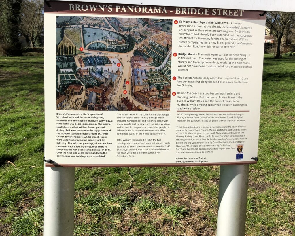
7 Bridge Street
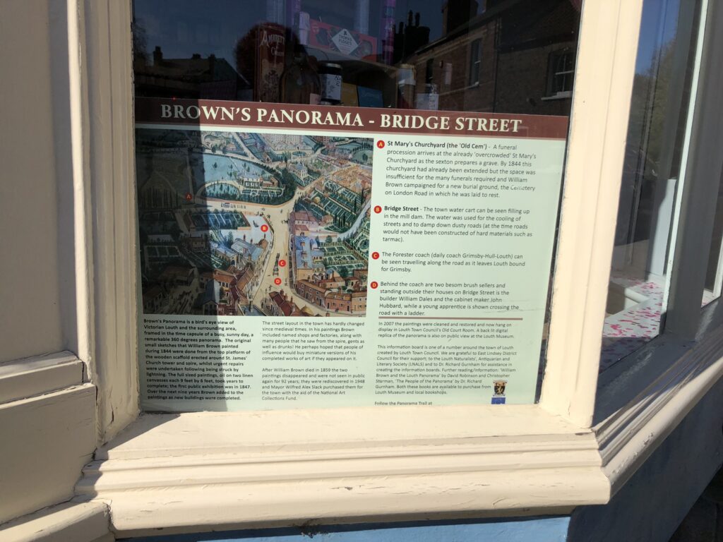
William Brown showed the town water cart filling up in the mill dam, the Forester coach travelling along the road, bound for Grimsby, tradesmen chatting and brush sellers trying to sell their goods. Walk along further, bear left through the small car park, and up to the entrance to St. Mary’s Cemetery, known as the ‘Old Cem’. This was a very busy and overcrowded cemetery, where burials would take place regularly. But it would be replaced by the London Road Cemetery. Go back to the small car park and carefully cross the busy road. Walk up the Grimsby Road until you reach High Holme Road on your right. Turn onto this road and you will soon reach the Hospital, which was once the Workhouse.
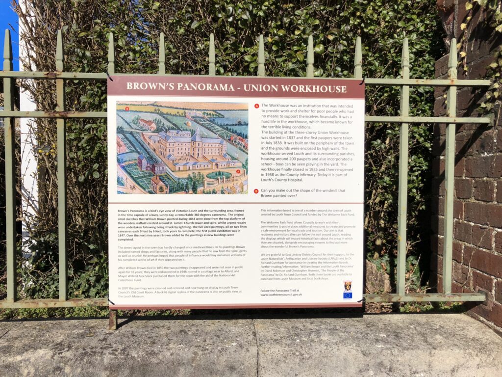
8 Union Workhouse
The workhouse was an institution that was intended to provide work and shelter for poor people who had no means to support themselves financially. It served 86 parishes, mostly within the circle of the Panorama. It was a very hard life in the workhouse with terrible living conditions. There were usually about 200 paupers within its walls, in the early years of the workhouse just over half of these were under 15 years of age. The Workhouse closed in 1935 and reopened as the County Infirmary in 1938. Next to the workhouse on its eastern side, was an impressive three storey house, 10 Holmes Lane, with an elaborate walled greenhouse at the end of a long garden. This became a ladies’ boarding school at which Andreas Kalvos, the famous Greek poet taught. Walk eastwards along High Holme Road for 350m and on your right, turn down Hawthorne Avenue. Only in the early 20th century did Hawthorne Avenue become a road linking High Holme Road to Charles Street. In this area Brown painted John Sanderson’s Ironworks. Walk down to the end of Hawthorne Avenue and turn right on to Charles Street.
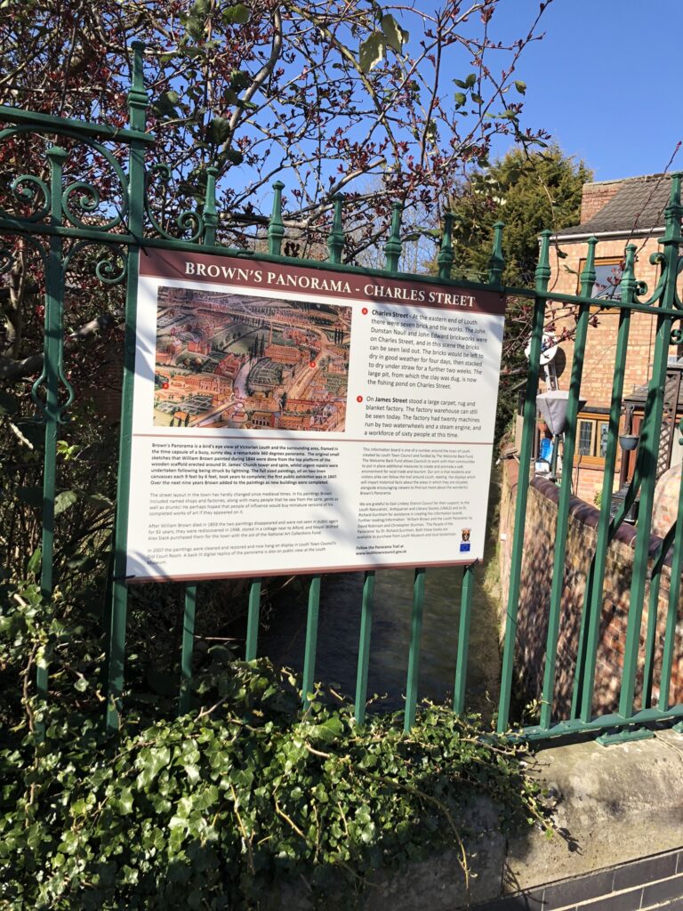
9 Charles Street
You pass the Charles Street tennis courts. Behind the tennis courts is the fishing pond; this was once the large pit from which clay was dug to make bricks. There were seven brick and tile works in Louth. Further down Charles Street was the area where the workers laid out the bricks to dry in the sun. Carry on down this road and turn left into James Street.
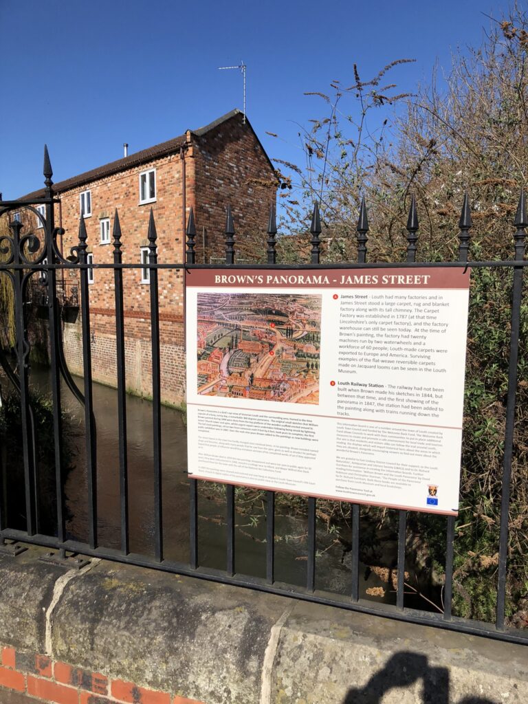
10 James Street
Walk along and you will pass on your right the Technical School (now a nursery) built at the end of the 19th century. Walk further on and on your left you come to the building which was the site of Louth’s carpet and rug factory warehouse (see the blue plaque). This was once part of a very busy factory with twenty machines run by two waterwheels and a steam engine. On Brown’s Panorama, a series of horses can be seen transporting goods along this road. Carry on walking and at the end of the road turn left onto Ramsgate and walk to the roundabout. Look to your left and in front of you, towards the retail estate and behind Aldi. This area was the site of the railway station (that Brown added to his painting) along with trains travelling along the tracks. The original station building, now converted into flats, can still be accessed from Station Approach. Turn back and walk back along Ramsgate and at the end of the road is the War Memorial, built in 1921 by public subscription. (www.louthtowncouncil.gov.uk/louth-war-memorial/).
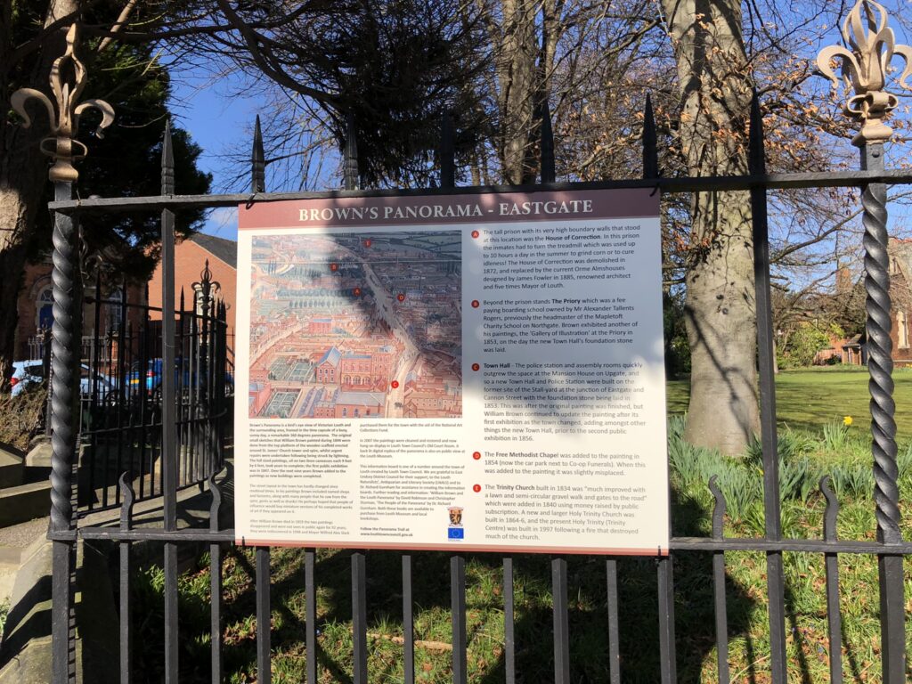
11 Eastgate
The area inside the black painted wrought iron fence was once the House of Correction. The tall prison comprised of the cells, a treadmill, the governor’s house, the Petty Sessions Court and the new Sessions House. The prisoners were kept in by a 23 foot high wall. In the prison, the inmates had to turn the treadmill which was used up to 10 hours a day in the summer to grind corn or to cure idleness! The buildings were demolished in 1872 and replaced by the current Orme Almshouses designed by James Fowler, renowned architect and five times Mayor of Louth. Walk eastwards along this part of Eastgate, known as Watery Lane in former years and pass by The Priory (now a hotel) which was at the time a fee paying boarding school. Thomas Espin (1767-1822) built the house between 1812 and 1818. In 1790 he had been appointed Master of the Mapletoft School in Louth. The school was officially named the Mathematical, Architectural, Nautical and Commercial Academy. When the Priory was finished in 1818, Espin used it to provide accommodation for boarding pupils. Espin was a talented artist and draughtsman. In 1805 he was asked to supervise the rebuilding of the belfry windows of St. James’ Church. He drew a plan of Louth (see inside back cover) and later he was invited to design a new Town Hall, although this was never built. In the grounds of the Priory he built himself a small summerhouse where he could sit and work.
After his death in 1822 the summerhouse became his mausoleum. Carry on walking eastwards for 300m and you will pass the Trinity Centre on your right. The first Holy Trinity church was built in 1834 to serve the growing population of the Riverhead and was improved in 1840 by public subscription. A new and larger Holy Trinity Church was built in 1864-6; the present Holy Trinity (Trinity Centre) was built in 1997 following a fire that destroyed much of the church. Walk a further 200m and you will arrive at Riverhead Road, walk down here to the Navigation Canal.
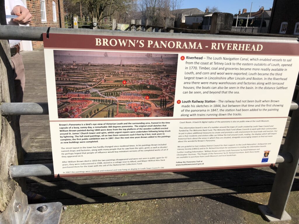
12 Riverhead
The Louth Navigation Canal enabled vessels to sail from the coast at Tetney Lock to the eastern outskirts of Louth, and many goods then became more readily available in the town, and corn and wool were exported. This area was very busy and filled with warehouses, workshops and terraced houses however with the arrival of the railway it began to fall into decline. In the distance, Saltfleet and the sea could be seen. Walk back up to Eastgate, and then back towards the town centre, until you reach the War Memorial again (850m). Cross over to the southern side of the road and turn left onto Church Street. This end of Church Street was known as Maiden Row (because the dirty muddy road resembled a midden or dungheap), and the southern end was called Long Lane. Halfway up Church Street turn right onto St Michael’s Road, and at the top turn right onto Newmarket. Cross this road at the crossing onto Linden Walk and in 200m you will reach the entrance to the Cemetery.
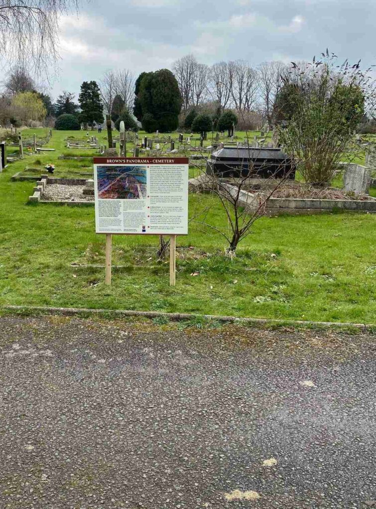
13 Cemetery
William Brown began campaigning for a new cemetery in 1843. This was due to the poor condition of St. Mary’s burial ground which was reaching capacity, there is a particularly graphic account involving bones being visible, written by Brown of, ‘the filling in of the grave of Mrs. Good’. William Brown finally saw the formation of the ‘Louth Cemetery Company’ in 1852 (nine years after his first complaint) which resulted in the purchase of ten-and-a-half acres of land at Julian Bower. In 1854 the ground was cleared and to illustrate this, Brown altered his painted canvas and added felled trees to replace his original large clump of trees. Interestingly, the Greenwich Meridian not only cuts through Louth town centre it also dissects the Louth Cemetery – so for over 150 years local families have had the choice of being buried in either the eastern or the western hemispheres of the world!
Walk back down Linden Walk (once called Green-Lane) and at the end turn left along Newmarket. On your left is the Livestock Market, which now runs on Mondays, and the adjacent Boars Head public House. Cross the road and on the corner is St. Mary’s Roman Catholic Church rebuilt in 1833 and the priest’s house that was added in 1839. The road beyond the crossroads is South Street; on the painting sheep can be seen being herded along here on their way to the livestock market. Just off South Street is Spital Hill, thought to be the site of a leper hospital and of the town gallows in the medieval period. Cross over, using the pedestrian crossing, turn right and follow Upgate all the way down; the same journey the London Royal Mail Coach would have taken. Pass the Mansion House, again, and finally arrive back at the ‘cobbles’ of St. James’ Church where our journey comes to an end. It was in this church in October 1536 that the Lincolnshire Rising began, and for his part, the vicar was hanged, drawn and quartered.